
The application system tracks the special victim DNA from crime scene through laboratory to the investigative branch ensuring timely notification to the invesigators. Elimintes procedural errors and enhances overall situational investigative awareness.
- Over 400,000 SAKI Kits Pending Nationwide
- Govt. spent over $1B to address this issue
- Law Enforcement Officers need help with automation to say focus on improtant tasks

Mission
Ensuring the timely, accurate tracking and notification of evidence for investigative accountability
Tracking & Notification
- AI Based Data Capture
- Secure Onsite or GovCloud Service
- iOS and Android Mobile App
- Data Analytics and Delay Detection
- Mobile Push Notifications
- Biometrics ID Management with TouchID, Faced, Voice, Face & Sound
Application Features
- Evidence Process Awareness
- Evidence Tracking Awareness
- AI Based Case Management Tool Integration
- Automated Notifications
- Investigative Compliance and Accountability
- Investigate Support Tool
- Configurable Timetable for Evidence Tracking and reminders
This user-friendly application will track your investigative evidence such as DNA, Latent Prints, as well as other trace evidences from the crime scene through the laboratory analysis into the hands of the detectives/investigators, cheifs and management in a timely fashion for the special victim. configurable circuit breakers to avoid systemic failures.
Extended Features
Can be utilized for tracking cases like Homicide, Fingerprints, Violent Crimes, Property Crimes or any crime involving multi agencies.
Tracking Drones Feature built in our App using Remote ID
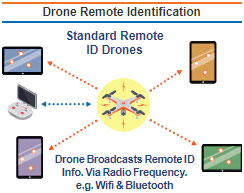
- Remote ID capability is built into the drone
- From takeoff to shutdown, drone broadcasts:
- Drone ID
- Drone location and altitude
- Drone velocity
- Control station location and elevation
- Time mark
- Emergency status
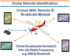
- Remote ID capability through module attched to drone
- Limited to visual line of sight operations
- From takeoff to shutdown, drone broadcasts:
- Drone ID
- Drone location and altitude
- Drone velocity
- Takeoff location and elevation
- Time mark
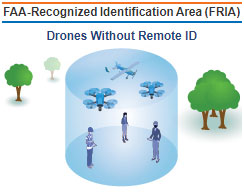
- Drones without Remote ID can operate without broadcasting
- Drones without Remote ID must operate within visual line of sight and within the FRIA
- Anyone can fly there, but FRIAs can only be requested by community-based organizations and educational institutions